Industries
Drawing on decades of unwavering industry leadership, we stand at the forefront of innovation and reliability
Industries We Serve
Oil & Gas
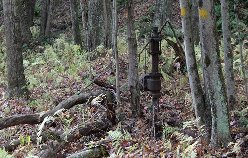
Our customers, including oil/gas companies, regulators, and drone companies, look to Sawback Technologies on how to integrate complex sensors, including magnetometers, methane sensors, and how to process the collected data. We’ve worked with customers to find undocumented infrastructure over various landscapes, ranging from Pennsylvania (USA) to British Columbia (Canada).
Drones equipped with the Sawback EdgeFuse can be deployed with multiple sensor technologies, including magnetometer, ground penetrating radar, and gas, to cover large and complex areas where legacy oil/gas activity has occurred, and reduce the time spent in the field, while keeping their personnel safe.
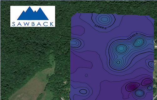
The data from these sensors is then automatically processed, with probable locations of oil/gas wells identified within minutes. Using this data, customers can reduce their liability from unknown oil/gas infrastructure, identify emissions and other pollution, and to support EPA Class VI permit applications.
Projects that customers have done to date include flying a 12,500 acre (50 sq.km) area in a heavily forest with steep terrain, and seeing a 60% reduction in the amount of effort and cost.
Class VI Permit
EPA Class VI permit applications for carbon capture and storage projects require magnetometry surveys if the project area has legacy oil/gas wells. These wells are often located in areas that are inaccessible to helicopters, grown over with heavy vegetation, steep terrain, or waterbodies, making them expensive to find through traditional ground surveys.
Using drone-mounted EdgeFuse and magnetometer sensors can make this daunting task easier. Being able to cover large areas of land, and processing the data in-flight, makes this a more cost-effective, comprehensive, and safe, solution to find these lost wells.
Drones
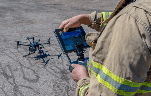
Drone operators spend too much time setting up sensors and processing data instead of flying.
Sawback Technologies simplifies this by enabling quick data and power connections for multiple sensors like magnetometers, ground-penetrating radar, and gas detectors. Its’ easy-to-use interface and weatherproof connectors ensure reliable data collection, reducing rework and maximizing flight time.
The Sawback Technologies EdgeFuse also processes and fuses data in-flight, providing near real-time insights. Once uploaded to the Sawback cloud-based software platform, automated reporting delivers results in popular formats, ready for use.
Want to streamline your workflow? Contact us to learn more!
Infrastructure
Making a detailed map of where voids are in that concrete pad or roadway, as well as other items, like knowing the thickness of concrete, or the depth of your bedrock, all of which is made easier with our automated software. You can collect your data, and send it to the cloud for rapid analysis and visualization, and plan your activities.

Let’s connect
Their commitment to providing a better way of doing things is palpable in every aspect of their work. By seamlessly blending their diverse skillsets and extensive work experiences, Sawback Technologies has crafted a cutting-edge solution that addresses and diminishes the pain points inherent in the near-surface industry.
Sawback delivered on their promise to providing a faster way of finding abandoned wells, and making the data easy to use and read